 |
Earth Observation Mission CFI Software DataHandling Software User Manual |
 |
 |
Earth Observation Mission CFI Software DataHandling Software User Manual |
 |
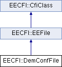
Class for reading DEM configuration files. More...

Public Member Functions | |
| DemConfFile () | |
| Default constructor. | |
| DemConfFile (const std::string &fileNam) | |
| Constructor with file name. | |
| DemConfFile (const DemConfFile &other) | |
| ~DemConfFile () NOEXCEPT | |
| Destructor. | |
| DemConfFile & | operator= (const DemConfFile &other) |
| void | read () |
| Read the data block and store it in object. | |
Public Attributes | |
| long | model |
| std::string | dir |
| Directory for the the DEM files. | |
| double | resX |
| Interval between points along X-axis. | |
| double | resY |
| Interval between points along Y-axis. | |
| double | resUnit |
| i.e. if res_X is given in seconds and X in degrees => res_unit=3600 | |
| long | XNumPoints |
| Number of points along X-axis (columns). | |
| long | YNumPoints |
| Number of points along Y-axis (lines)). | |
| double | xRange |
| longitude of the x-axis for one file (grid). | |
| double | yRange |
| longitude of the y-axis for one file (grid). | |
| long | dataSize |
| Size in bytes of the data stored in the files. | |
| long | dataType |
| Data type (int, long, float, double). | |
| double | northAlt [4] |
| Altitude at the North pole cell. | |
| double | southAlt [4] |
| Altitude at the South pole cell. | |
| double | offsetX |
| double | offsetY |
| long | metadataModel |
| DEM model. | |
| std::string | userDirectory |
| User directory. | |
| long | cacheType |
| Cache type (DemCacheTypeEnum). | |
| long | cacheMaxSize |
| CacheMaxSize (measured in MB). | |
| DemMiniTiles | miniTiles |
| DEM mini tiles configuration. | |
| long | geoidComputation |
| Geoid computation flag (DemGeoidFlagEnum). | |
| long | geoidNumHarmonics |
| Number of harmonics to be used in geoid computations. | |
| long | nRows |
| Number of rows (for whole DEM). | |
| long | nCols |
| Number of columns (for whole DEM). | |
| long | cellLocation |
| Cell location (DemCellLocationEnum). | |
| DemRaster | demRaster |
| Configuration for model DEM GENERIC raster. | |
Class for reading DEM configuration files.
| EECFI::DemConfFile::DemConfFile | ( | ) |
Default constructor.
| EECFI::DemConfFile::DemConfFile | ( | const std::string & | fileNam | ) | [explicit] |
Constructor with file name.
| EECFI::DemConfFile::DemConfFile | ( | const DemConfFile & | other | ) |
| EECFI::DemConfFile::~DemConfFile | ( | ) |
Destructor.
| DemConfFile & EECFI::DemConfFile::operator= | ( | const DemConfFile & | other | ) |
Copy assigment operator.
| other | The DemConfFile to copy/assign from |
References cacheMaxSize, cacheType, cellLocation, dataSize, dataType, demRaster, dir, geoidComputation, geoidNumHarmonics, metadataModel, miniTiles, model, nCols, northAlt, nRows, offsetX, offsetY, resUnit, resX, resY, southAlt, userDirectory, XNumPoints, xRange, YNumPoints, and yRange.
| void EECFI::DemConfFile::read | ( | ) |
Read the data block and store it in object.
References cacheMaxSize, cacheType, cellLocation, dataSize, dataType, demRaster, dir, EECFI::DemMiniTiles::fileName, EECFI::EEFile::fileName, geoidComputation, geoidNumHarmonics, EECFI::DemMiniTiles::latSize, EECFI::DemMiniTiles::lonSize, metadataModel, miniTiles, model, nCols, northAlt, nRows, offsetX, offsetY, resUnit, resX, resY, southAlt, EECFI::CfiClass::throwWarn, userDirectory, XNumPoints, xRange, YNumPoints, and yRange.
CacheMaxSize (measured in MB).
Referenced by operator=(), EECFI::DemFile::read(), and read().
Cache type (DemCacheTypeEnum).
Referenced by operator=(), EECFI::DemFile::read(), and read().
Cell location (DemCellLocationEnum).
Referenced by operator=(), EECFI::DemFile::read(), and read().
Size in bytes of the data stored in the files.
Referenced by operator=(), EECFI::DemFile::read(), and read().
Data type (int, long, float, double).
Referenced by operator=(), EECFI::DemFile::read(), and read().
Configuration for model DEM GENERIC raster.
Referenced by operator=(), EECFI::DemFile::read(), and read().
| std::string EECFI::DemConfFile::dir |
Directory for the the DEM files.
Referenced by operator=(), EECFI::DemFile::read(), and read().
Geoid computation flag (DemGeoidFlagEnum).
Referenced by operator=(), EECFI::DemFile::read(), and read().
Number of harmonics to be used in geoid computations.
Referenced by operator=(), EECFI::DemFile::read(), and read().
DEM model.
Referenced by operator=(), EECFI::DemFile::read(), and read().
DEM mini tiles configuration.
Referenced by operator=(), EECFI::DemFile::read(), and read().
Referenced by operator=(), EECFI::DemFile::read(), and read().
Number of columns (for whole DEM).
Referenced by operator=(), EECFI::DemFile::read(), and read().
| double EECFI::DemConfFile::northAlt[4] |
Altitude at the North pole cell.
Referenced by DemConfFile(), operator=(), EECFI::DemFile::read(), and read().
Number of rows (for whole DEM).
Referenced by operator=(), EECFI::DemFile::read(), and read().
| double EECFI::DemConfFile::offsetX |
Referenced by operator=(), EECFI::DemFile::read(), and read().
| double EECFI::DemConfFile::offsetY |
Offsets. For ANR - 187: The points will be given for the center of a cell instead of the corners. The offset is the difference betweeen the center of the cell an the side of the cell (in degrees).
Referenced by operator=(), EECFI::DemFile::read(), and read().
| double EECFI::DemConfFile::resUnit |
i.e. if res_X is given in seconds and X in degrees => res_unit=3600
Conversion factor from x,y units to the res_X, res_Y units.
Referenced by operator=(), EECFI::DemFile::read(), and read().
| double EECFI::DemConfFile::resX |
Interval between points along X-axis.
Referenced by operator=(), EECFI::DemFile::read(), and read().
| double EECFI::DemConfFile::resY |
Interval between points along Y-axis.
Referenced by operator=(), EECFI::DemFile::read(), and read().
| double EECFI::DemConfFile::southAlt[4] |
Altitude at the South pole cell.
Referenced by operator=(), EECFI::DemFile::read(), and read().
| std::string EECFI::DemConfFile::userDirectory |
User directory.
Referenced by operator=(), EECFI::DemFile::read(), and read().
Number of points along X-axis (columns).
Referenced by operator=(), EECFI::DemFile::read(), and read().
| double EECFI::DemConfFile::xRange |
longitude of the x-axis for one file (grid).
Referenced by operator=(), EECFI::DemFile::read(), and read().
Number of points along Y-axis (lines)).
Referenced by operator=(), EECFI::DemFile::read(), and read().
| double EECFI::DemConfFile::yRange |
longitude of the y-axis for one file (grid).
Referenced by operator=(), EECFI::DemFile::read(), and read().
 1.7.1
1.7.1