Earth Observation Mission CFI Software Lib Software User Manual |
Earth Observation Mission CFI Software Lib Software User Manual |
Data structure defining the geodetic coordinates. More...
Public Member Functions | |
| Geodetic () | |
| Default constructor. | |
| Geodetic (double lon, double lat, double alt) | |
| Class constructor without derivatives. | |
| Geodetic (double lon, double lat, double alt, double lonDer, double latDer, double altDer) | |
| Class constructor with derivatives. | |
| double | geoDistance (const ModelId &modelId, double lon, double lat, double &az_1to2, double &az_2to1) const |
| Get distance between the geodetic point and another one located at the the same altitude with the input longitude and latitude [m]. | |
Public Attributes | |
| long | deriv |
| derivative flag (XLCFI_NO_DER or XLCFI_DER_1ST). | |
| double | lon |
| longitude. | |
| double | lat |
| latitude. | |
| double | alt |
| altitude. | |
| double | lonDer |
| longitude 1st. derivative. | |
| double | latDer |
| latitude 1st. derivative. | |
| double | altDer |
| altitude 1st. derivative. | |
Data structure defining the geodetic coordinates.
| EECFI::Geodetic::Geodetic | ( | ) | [inline] |
Default constructor.
| EECFI::Geodetic::Geodetic | ( | double | lon, | |
| double | lat, | |||
| double | alt | |||
| ) |
Class constructor without derivatives.
| EECFI::Geodetic::Geodetic | ( | double | lon, | |
| double | lat, | |||
| double | alt, | |||
| double | lonDer, | |||
| double | latDer, | |||
| double | altDer | |||
| ) |
Class constructor with derivatives.
| double EECFI::Geodetic::geoDistance | ( | const ModelId & | modelId, | |
| double | longitude, | |||
| double | latitude, | |||
| double & | az_1to2, | |||
| double & | az_2to1 | |||
| ) | const |
Get distance between the geodetic point and another one located at the the same altitude with the input longitude and latitude [m].
The geoDistance method calculates the geodesic distance between two points that lay on the same ellipsoid, and the azimuth of the related geodesic line at both points. See diagram below.
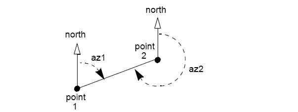
| modelId | Model id. | |
| longitude | Longitude of the second point. Allowed range=[0, 360) | |
| latitude | Latitude of the second point. Allowed range=[-90, 90] | |
| az_1to2 | [OUTPUT] azimuth of the geodesic line from point 1 to 2. | |
| az_2to1 | [OUTPUT] azimuth of the geodesic line from point 2 to 1. |
References alt, lat, lon, and EECFI::CfiClass::throwWarn.
| double EECFI::Geodetic::alt |
altitude.
Referenced by geoDistance().
| double EECFI::Geodetic::altDer |
altitude 1st. derivative.
derivative flag (XLCFI_NO_DER or XLCFI_DER_1ST).
| double EECFI::Geodetic::lat |
latitude.
Referenced by geoDistance().
| double EECFI::Geodetic::latDer |
latitude 1st. derivative.
| double EECFI::Geodetic::lon |
longitude.
Referenced by geoDistance().
| double EECFI::Geodetic::lonDer |
longitude 1st. derivative.
 1.7.1
1.7.1