Earth Observation Mission CFI Software Lib Software User Manual for JAVA |
Earth Observation Mission CFI Software Lib Software User Manual for JAVA |
Data structure defining the geodetic coordinates. More...
Public Member Functions | |
| Geodetic () | |
| Class constructor. | |
| Geodetic (double longitud, double latitude, double altitud) | |
| Class constructor with parameters (without derivatives). | |
| Geodetic (double longitud, double latitude, double altitud, double longitudDer, double latitudeDer, double altitudeDer) | |
| Class constructor with parameters with derivatives. | |
| native GeoDistance | geoDistance (final ModelId modelId, double lon, double lat) throws CfiError |
| Get distance between two geodetic points. | |
Public Attributes | |
| long | deriv |
| derivative flag (XLCFI_NO_DER or XLCFI_DER_1ST). | |
| double | lon |
| longitude. | |
| double | lat |
| latitude. | |
| double | alt |
| altitude. | |
| double | lonDer |
| longitude 1st. derivative. | |
| double | latDer |
| latitude 1st. derivative. | |
| double | altDer |
| altitude 1st. derivative. | |
Data structure defining the geodetic coordinates.
| EECFI.Geodetic.Geodetic | ( | ) |
Class constructor.
| EECFI.Geodetic.Geodetic | ( | double | longitud, | |
| double | latitude, | |||
| double | altitud | |||
| ) |
Class constructor with parameters (without derivatives).
| EECFI.Geodetic.Geodetic | ( | double | longitud, | |
| double | latitude, | |||
| double | altitud, | |||
| double | longitudDer, | |||
| double | latitudeDer, | |||
| double | altitudeDer | |||
| ) |
Class constructor with parameters with derivatives.
| GeoDistance EECFI.Geodetic::geoDistance | ( | final ModelId | modelId, | |
| double | lon, | |||
| double | lat | |||
| ) | throws CfiError |
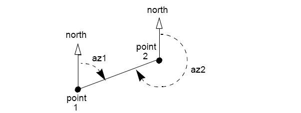
Get distance between two geodetic points.
The geoDistance method calculates the geodesic distance between two points that lay on the same ellipsoid, and the azimuth of the related geodesic line at both points. See diagram below.
| modelId | Model id. | |
| lon | Longitude of the second point. Allowed range=[0, 360) | |
| lat | Latitude of the second point. Allowed range=[-90, 90] |
| double EECFI.Geodetic.alt |
altitude.
| double EECFI.Geodetic.altDer |
altitude 1st. derivative.
| long EECFI.Geodetic.deriv |
derivative flag (XLCFI_NO_DER or XLCFI_DER_1ST).
| double EECFI.Geodetic.lat |
latitude.
| double EECFI.Geodetic.latDer |
latitude 1st. derivative.
| double EECFI.Geodetic.lon |
longitude.
| double EECFI.Geodetic.lonDer |
longitude 1st. derivative.
 1.7.1
1.7.1