Earth Observation Mission CFI Software Visibility Software User Manual for JAVA |
Earth Observation Mission CFI Software Visibility Software User Manual for JAVA |
Class to make operations involving a swath for zone and station visibility. More...

Public Member Functions | |
| Swath () | |
| Empty Class finalructor. | |
| Swath (final OrbitId orbitId, String swathFileName) throws CfiError | |
| Class constructor with parameters for STF file. | |
| Swath (final OrbitId orbitId, long orbitNum, String swathFileName) throws CfiError | |
| Class constructor with parameters for SDF file. | |
| void | set (final OrbitId orbitId, String swathFileName) throws CfiError |
| Set values of parameters with STF file. | |
| void | set (final OrbitId orbitId, long orbitNum, String swathFileName) throws CfiError |
| Set values of parameterswith SDF file. | |
| void | set (final AtmosId atmosId) throws CfiError |
| Set Atmosphere Id, necessary for swath generation. | |
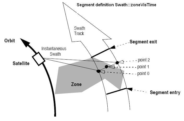
| VisibilityList | zoneVisTime (long startOrbit, long stopOrbit, String zoneId, String zoneDBFile, long projection, double minDuration) throws CfiError |
| Calculate zone visibility segments using a zone database. | |
| VisibilityList | zoneVisTime (long startOrbit, long stopOrbit, long projection, final ZoneRec zoneRec, double minDuration) throws CfiError |
| Calculate zone visibility segments using a zone rec. | |
| native VisibilityList | zoneVisTime (long startOrbit, long stopOrbit, long projection, final StfFile stfFile, final ZoneRec zoneRec, double minDuration) throws CfiError |
| Calculate zone visibility segments using a STF object and ZoneRec. | |
| native VisibilityList | stationVisTime (long startOrbit, long stopOrbit, String staId, String staDBFile, long mask, double aosElevation, double losElevation, double minDuration) throws CfiError |
| Calculate the visibility segments for which a satellite is visible from a ground station. | |
| native VisibilityList | stationVisTime (long startOrbit, long stopOrbit, final StfFile stfFile, final StationRec staRec, long mask, double aosElevation, double losElevation, double minDuration) throws CfiError |
| Calculate the visibility segments for which a satellite is visible from a ground station. | |
| native VisibilityList | multiZonesVisTime (long startOrbit, long stopOrbit, final Vector< String > zoneId, String zoneDBFile, long[] projection, final Vector< ZoneRec > zoneRec, double minDuration, boolean extraInfoFlag) throws CfiError |
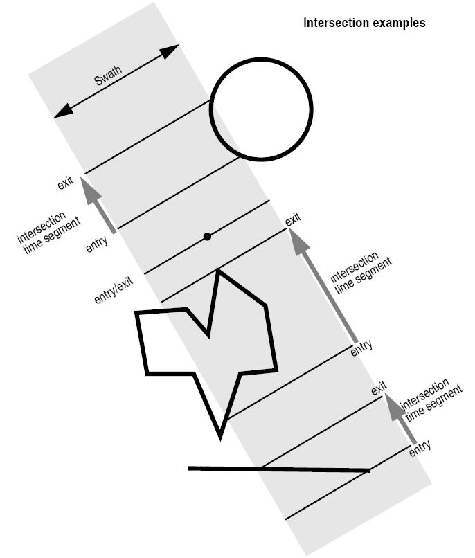
| Calculates visibility segments for which the swath intersects a set of zones on the Earth ellipsoid. | |
| native VisibilityList | multiStationsVisTime (long startOrbit, long stopOrbit, final Vector< String > staId, String staDBFile, double[] aosElevation, double[] losElevation, final long[] mask, double minDuration, boolean extraInfoFlag) throws CfiError |
| Calculates visibility segments for which a satellite is visible from a set of ground stations. | |
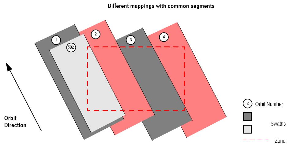
| Vector< VisibilityList > | mapping (long startOrbit, long stopOrbit, String zoneId, String zoneDBFile, long projection) throws CfiError |
| Computes groups of visibility segments that cover the visiblity of a zone read from a database. | |
| Vector< VisibilityList > | mapping (long startOrbit, long stopOrbit, long projection, final ZoneRec zoneRec) throws CfiError |
| Computes groups of visibility segments that cover the visiblity of a given zone. | |
| native String | genSwath (long requestedOrbit, String dirName, String swathFile, String fileClass, long versionNumber, String fhSystem) throws CfiError |
| Generate a swath template file using the SDF file. | |
| native StfFile | genSwath (long requestedOrbit, final SdfFile sdfFile) throws CfiError |
| Generate a STFFile object using the object SdfFile. | |
| native Vector< Geodetic > | getPos (final StfFile stfFile, final ANXTime anxTime) throws CfiError |
| Gets the location of a swath at a given ANXTime. | |
| native String | genScf (String instrument, final VisibilityList visList, final Vector< ScfAppear > scfApp, String dirName, String scfFileName, String fileClass, long versionNumber, String fhSystem) throws CfiError |
| Generate a swath control file. | |
Class to make operations involving a swath for zone and station visibility.
| EECFI.Swath.Swath | ( | ) |
Empty Class finalructor.
Class constructor with parameters for STF file.
| orbitId | Orbit Id. | |
| swathFileName | Swath template filename (path). |
| String EECFI.Swath::genScf | ( | String | instrument, | |
| final VisibilityList | visList, | |||
| final Vector< ScfAppear > | scfApp, | |||
| String | dirName, | |||
| String | scfFileName, | |||
| String | fileClass, | |||
| long | versionNumber, | |||
| String | fhSystem | |||
| ) | throws CfiError |
Generate a swath control file.
This file contains a list of visibility segments together with some features linked to the segment that are used for the visualisation of the segment in the ESOV tool.
| instrument | Instrument name. | |
| visList | Visibility segments. | |
| scfApp | Array with the structures containing the appearance for every segment. | |
| dirName | Directory where resulting STF is written. | |
| scfFileName | Name for output swath file. If empty ("") the software will generate the name according to file name specifications. | |
| fileClass | File class for output file. | |
| versionNumber | Version number of output file. Allowed range: >=1. | |
| fhSystem | System field of the output fixed header. |
| String EECFI.Swath::genSwath | ( | long | requestedOrbit, | |
| String | dirName, | |||
| String | swathFile, | |||
| String | fileClass, | |||
| long | versionNumber, | |||
| String | fhSystem | |||
| ) | throws CfiError |
Generate a swath template file using the SDF file.
If AtmosId is not set, default will be used.
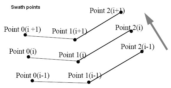
| Swath geometry definition (algorithm) Geometry |
Algorithm description | Swath point type |
|---|---|---|
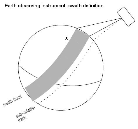
| Pointing_Geometry (azimuth, elevation, altitude) | Swath point computed with Target::targetInter with that azimuth, elevation and altitude | Geodetic |
| Distance_Geometry (azimuth, elevation, altitude, distance) | Swath point computed with Target::targetGroundRange with that azimuth, elevation, altitude and distance | Geodetic |
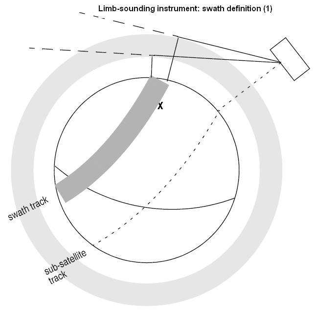
| Limb_Geometry (azimuth and altitude) | Swath point computed with Target::targetAltitude with that azimuth and altitude | Geodetic |
| Inertial_Geometry (azimuth and altitude) | Swath point computed with Target::targetAltitude with that azimuth and altitude. The swath point is the RA and Declination of the target. | Inertial |
| Sub_Satellite_Geometry (no parameters) | Computation of the sub-satellite point | Geodetic |
| ASAR_Geometry (azimuth, elevation, altitude) | Specific algorithm for the three swath points for ASAR instrument in Envisat. | Geodetic |
| requestedOrbit | Absolute orbit for which the instrument swath template file will be calculated. | |
| dirName | Directory where the resulting STF is written (current directory used ir empty string). | |
| swathFile | Name for output swath file (if empty, the name will be generated according to file name specifications). | |
| fileClass | File class for output swath file. | |
| versionNumber | Version number for output swath file. Allowed range: >=1. | |
| fhSystem | System field of the output swath file fixed header. |
Generate a STFFile object using the object SdfFile.
OrbitId must be set.
If AtmosId is not set, default will be used.
| requestedOrbit | Absolute orbit for which the instrument swath template file will be calculated. | |
| sdfFile | Swath Definition File object. It must have been read. |
| Vector< VisibilityList > EECFI.Swath::mapping | ( | long | startOrbit, | |
| long | stopOrbit, | |||
| long | projection, | |||
| final ZoneRec | zoneRec | |||
| ) | throws CfiError |
Computes groups of visibility segments that cover the visiblity of a given zone.
| startOrbit | First absolute orbit, segment filter; segments will be filtered as from the beginning of first orbit. First Orbit for the orbit initialization will be used when absolute orbit is set to zero. Allowed range: =0; or >=start_osf. | |
| stopOrbit | Last absolute orbit, segment filter. For orbitId initialized with orbital changes, when stopOrbit = 0 the stopOrbit will be set to the minimum value between:
Allowed range: =0; or >=start_osf. | |
| projection | Projection used to define the polygon sides as straight lines (ProjectionEnum). | |
| zoneRec | Zone definition. |
| Vector< VisibilityList > EECFI.Swath::mapping | ( | long | startOrbit, | |
| long | stopOrbit, | |||
| String | zoneId, | |||
| String | zoneDBFile, | |||
| long | projection | |||
| ) | throws CfiError |
Computes groups of visibility segments that cover the visiblity of a zone read from a database.
| startOrbit | First absolute orbit, segment filter; segments will be filtered as from the beginning of first orbit. First Orbit for the orbit initialization will be used when absolute orbit is set to zero. Allowed range: =0; or >=start_osf. | |
| stopOrbit | Last absolute orbit, segment filter. For orbitId initialized with orbital changes, when stopOrbit = 0 the stopOrbit will be set to the minimum value between:
Allowed range: =0; or >=start_osf. | |
| zoneId | Identification of the zone, as defined in zoneDBFile. | |
| zoneDBFile | File name of the zone database file. | |
| projection | Projection used to define the polygon sides as straight lines (ProjectionEnum). |
| VisibilityList EECFI.Swath::multiStationsVisTime | ( | long | startOrbit, | |
| long | stopOrbit, | |||
| final Vector< String > | staId, | |||
| String | staDBFile, | |||
| double[] | aosElevation, | |||
| double[] | losElevation, | |||
| final long[] | mask, | |||
| double | minDuration, | |||
| boolean | extraInfoFlag | |||
| ) | throws CfiError |
Calculates visibility segments for which a satellite is visible from a set of ground stations.
| startOrbit | First absolute orbit, segment filter; segments will be filtered as from the beginning of first orbit. First Orbit for the orbit initialization will be used when absolute orbit is set to zero. Allowed range: =0; or >=start_osf. | |
| stopOrbit | Last absolute orbit, segment filter. For orbitId initialized with orbital changes, when stopOrbit = 0 the stopOrbit will be set to the minimum value between:
Allowed range: =0; or >=start_osf. | |
| staId | Identification of the stations, as defined in staDBFile. | |
| staDBFile | File name of the station database file. | |
| mask | Mask used to define visibility (MaskEnum). | |
| aosElevation | Minimum elevation to consider at AOS [deg]. Allowed range: >=0.0. | |
| losElevation | Maximum elevation to consider at LOS [deg]. Allowed range: >=0.0 ; <=aosElevation. | |
| minDuration | Minimum duration for segments; only segments with a duration longer than minDuration will be given as output [s]. Allowed range: >=0. | |
| extraInfoFlag | If true, numberOfStations and stationsInSegment are calculated (see VisibilitySegment.h). |
| VisibilityList EECFI.Swath::multiZonesVisTime | ( | long | startOrbit, | |
| long | stopOrbit, | |||
| final Vector< String > | zoneId, | |||
| String | zoneDBFile, | |||
| long[] | projection, | |||
| final Vector< ZoneRec > | zoneRec, | |||
| double | minDuration, | |||
| boolean | extraInfoFlag | |||
| ) | throws CfiError |
Calculates visibility segments for which the swath intersects a set of zones on the Earth ellipsoid.
| startOrbit | First absolute orbit, segment filter; segments will be filtered as from the beginning of first orbit. First Orbit for the orbit initialization will be used when absolute orbit is set to zero. Allowed range: =0; or >=start_osf. | |
| stopOrbit | Last absolute orbit, segment filter. For orbitId initialized with orbital changes, when stopOrbit = 0 the stopOrbit will be set to the minimum value between:
Allowed range: =0; or >=start_osf. | |
| zoneId | Identification of the zones (it must be one for every zone, not only the ones read from database, but the stations read from database must be placed first in vector). | |
| zoneDBFile | File name of the zone database file. | |
| projection | Projection used to define the polygon sides as straight lines (ProjectionEnum). | |
| zoneRec | Zones definition. | |
| minDuration | Minimum duration for segments; only segments with a duration longer than minDuration will be given as output [s]. Allowed range: >=0. | |
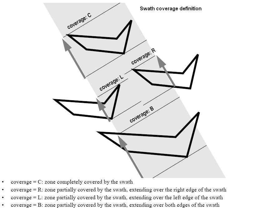
| extraInfoFlag | If true, numberOfZones, zonesInSegment and multiCoverage are calculated (see VisibilitySegment.h). |
Set values of parameters with STF file.
| orbitId | Orbit Id. | |
| swathFileName | Swath template filename (path). |
Set Atmosphere Id, necessary for swath generation.
| atmosId | Atmosphere Id. |
| VisibilityList EECFI.Swath::stationVisTime | ( | long | startOrbit, | |
| long | stopOrbit, | |||
| String | staId, | |||
| String | staDBFile, | |||
| long | mask, | |||
| double | aosElevation, | |||
| double | losElevation, | |||
| double | minDuration | |||
| ) | throws CfiError |
Calculate the visibility segments for which a satellite is visible from a ground station.
| startOrbit | First absolute orbit, segment filter; segments will be filtered as from the beginning of first orbit. First Orbit for the orbit initialization will be used when absolute orbit is set to zero. Allowed range: =0; or >=start_osf. | |
| stopOrbit | Last absolute orbit, segment filter. For orbitId initialized with orbital changes, when stopOrbit = 0 the stopOrbit will be set to the minimum value between:
Allowed range: =0; or >=start_osf. | |
| staId | Identification of the station, as defined in staDBFile. | |
| staDBFile | File name of the station database file. | |
| mask | Mask used to define visibility (MaskEnum in VisibilityData.h). | |
| aosElevation | Minimum elevation to consider at AOS [deg]. Allowed range: >=0.0. | |
| losElevation | Maximum elevation to consider at LOS [deg]. Allowed range: >=0.0 ; <=aosElevation. | |
| minDuration | Minimum duration for segments; only segments with a duration longer than minDuration will be given as output [s]. Allowed range: >=0. |
| VisibilityList EECFI.Swath::stationVisTime | ( | long | startOrbit, | |
| long | stopOrbit, | |||
| final StfFile | stfFile, | |||
| final StationRec | staRec, | |||
| long | mask, | |||
| double | aosElevation, | |||
| double | losElevation, | |||
| double | minDuration | |||
| ) | throws CfiError |
Calculate the visibility segments for which a satellite is visible from a ground station.
| startOrbit | First absolute orbit, segment filter; segments will be filtered as from the beginning of first orbit. First Orbit for the orbit initialization will be used when absolute orbit is set to zero. Allowed range: =0; or >=start_osf. | |
| stopOrbit | Last absolute orbit, segment filter. For orbitId initialized with orbital changes, when stopOrbit = 0 the stopOrbit will be set to the minimum value between:
Allowed range: =0; or >=start_osf. | |
| stfFile | StfFile object with STF information. File must have been read. | |
| staRec | Station data. | |
| mask | Mask used to define visibility (MaskEnum). | |
| aosElevation | Minimum elevation to consider at AOS [deg]. Allowed range: >=0.0. | |
| losElevation | Maximum elevation to consider at LOS [deg]. Allowed range: >=0.0 ; <=aosElevation. | |
| minDuration | Minimum duration for segments; only segments with a duration longer than minDuration will be given as output [s]. Allowed range: >=0. |
| VisibilityList EECFI.Swath::zoneVisTime | ( | long | startOrbit, | |
| long | stopOrbit, | |||
| long | projection, | |||
| final ZoneRec | zoneRec, | |||
| double | minDuration | |||
| ) | throws CfiError |
Calculate zone visibility segments using a zone rec.
| startOrbit | First absolute orbit, segment filter; segments will be filtered as from the beginning of first orbit. First Orbit for the orbit initialization will be used when absolute orbit is set to zero. Allowed range: =0; or >=start_osf. | |
| stopOrbit | Last absolute orbit, segment filter. For orbitId initialized with orbital changes, when stopOrbit = 0 the stopOrbit will be set to the minimum value between:
Allowed range: =0; or >=start_osf. | |
| projection | Projection used to define the polygon sides as straight lines (ProjectionEnum). | |
| zoneRec | Zone definition. | |
| minDuration | Minimum duration for segments; only segments with a duration longer than minDuration will be given as output [s]. Allowed range: >=0. |
| VisibilityList EECFI.Swath::zoneVisTime | ( | long | startOrbit, | |
| long | stopOrbit, | |||
| long | projection, | |||
| final StfFile | stfFile, | |||
| final ZoneRec | zoneRec, | |||
| double | minDuration | |||
| ) | throws CfiError |
Calculate zone visibility segments using a STF object and ZoneRec.
| startOrbit | First absolute orbit, segment filter; segments will be filtered as from the beginning of first orbit. First Orbit for the orbit initialization will be used when absolute orbit is set to zero. Allowed range: =0; or >=start_osf. | |
| stopOrbit | Last absolute orbit, segment filter. For orbitId initialized with orbital changes, when stopOrbit = 0 the stopOrbit will be set to the minimum value between:
Allowed range: =0; or >=start_osf. | |
| stfFile | Swath Template File object, it must have been read. | |
| zoneRec | Record with the zone information. | |
| projection | Projection used to define the polygon sides as straight lines (ProjectionEnum). | |
| zoneRec | Zone definition. | |
| minDuration | Minimum duration for segments; only segments with a duration longer than minDuration will be given as output [s]. Allowed range: >=0. |
| VisibilityList EECFI.Swath::zoneVisTime | ( | long | startOrbit, | |
| long | stopOrbit, | |||
| String | zoneId, | |||
| String | zoneDBFile, | |||
| long | projection, | |||
| double | minDuration | |||
| ) | throws CfiError |
Calculate zone visibility segments using a zone database.
| Instrument | Mode | File Prefix = swath | Swath geometry (table 59) | Swath Type | Remarks |
|---|---|---|---|---|---|
| RA | - | RA_2__ | POINTING (1 point) | Nadir point | Modeled as sub-satellite track |
| MERIS | Averaging / Direct & Averaging | MERIS_ | POINTING (3 points) | Nadir line | - |
| ASAR | Image Modes (IS1... IS7) | SARxIM (x=1...7) | ASAR | Nadir line | - |
| Alt. Polarization (IS1... IS7) | |||||
| Wide Swath | SARWIM | ||||
| Global Monitoring | |||||
| Wave (IS1... IS7) | SARxWV (x=1...7) | Modeled as a continuous swath anywhere within the image swath | |||
| GOMOS | Occultation | GOMOIL GOMOIH |
INERTIAL | Inertial direction | IFOV much smaller than swath. IFOV Very dependent on star availability. 2 swaths defined:
|
| Occultation | GOMO_H GOMO_L |
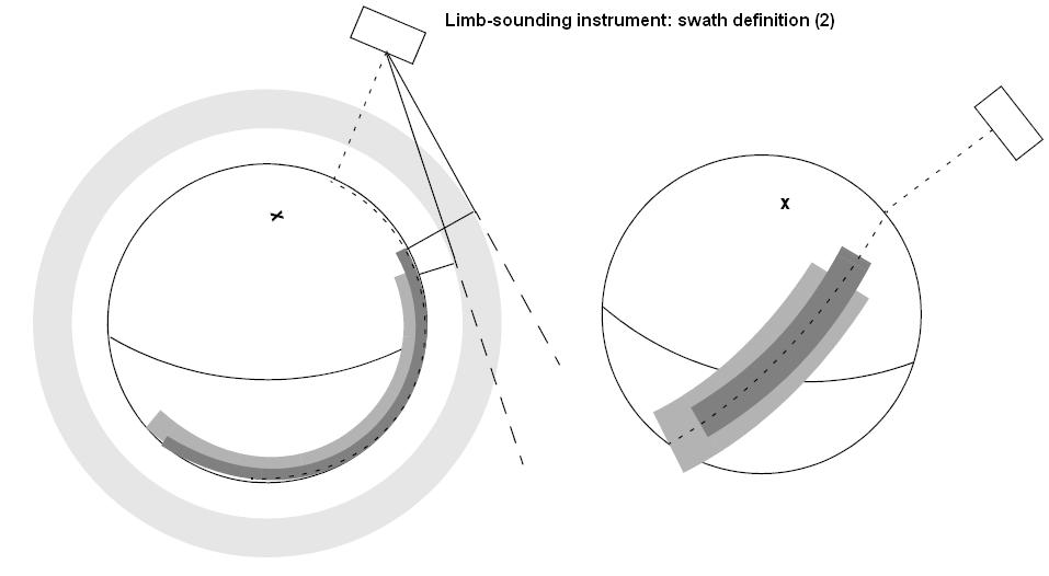
LIMB | Limb wide | Same mode as above, now swath defined as Earth-fixed location.
IFOV much smaller than swath. IFOV Very dependent on star availability. 2 swaths defined:
|
|
| SCIAMACHY | Nadir / Nadir of Nadir & Limb | SCIAN_ | POINTING (3 points) | Nadir line | Continuous Nadir swath modeled |
| Limb / Limb of Nadir & Limb | SCIALH SCIALL |
- | Limb wide | Same mode as above, now swath defined as Earth-fixed location.
IFOV much smaller than swath. IFOV Very dependent on star availability. 2 swaths defined:
|
|
| AATSR | - | ATSR_N ATSR_F |
POINTING (3 points) | Nadir line | 2 swaths defined:
|
| MWR | - | MWR___ | POINTING (1 points) | Nadir point | Modeled as sub-satellite track |
| MIPAS | Nominal | MIPN_H MIPN_L |
LIMB | Limb narrow | 2 swaths defined:
|
| Special Event Mode (across) | MIP_X_ | LIMB | Limb narrow | Modeled as an across track swath, in the middle of the MIPAS SEM acquisition scan. | |
| Special Event Mode (rearward) | MIP_RH MIP_RL |
LIMB | Limb wide | IFOV much smaller than swath.
2 swaths defined:
|
|
| Rearward | MIPIRH MIPIRL |
INERTIAL | Inertial direction | 2 swaths defined for rearward mode:
|
|
| Sideward | MIPIXH MIPIXL |
3 swaths defined for sideward mode:
|
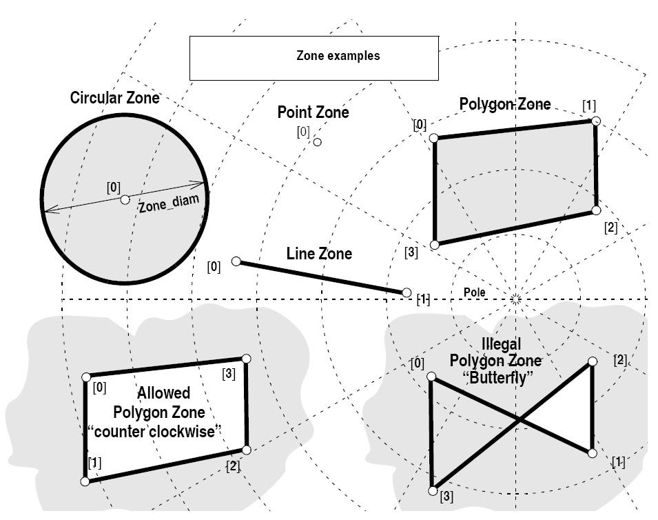
| Zone definition | Zone_num | Zone_long Zone_lat |
Zone_diam | Description |
|---|---|---|---|---|
| Circular Zone | 1 | [0]: centre point | yes zone_diam > 0.0 |
The zone is represented as a circle, around the centre point |
| Point Zone | 1 | [0]: Point | yes zone_diam = 0.0 |
The zone is defined by the point. Resulting segments will have a zero duration. The zone will always be completely covered by the swath. |
| Line Zone | 2 | [0], [1]: Line | no | The zone is defined by the line from point [0] to point [1]. |
| Polygon Zone | >2 | [i] | no | The zone is defined by the area right of the line from point [i] to point [i+1]. |
| startOrbit | First absolute orbit, segment filter; segments will be filtered as from the beginning of first orbit. First Orbit for the orbit initialization will be used when absolute orbit is set to zero. Allowed range: =0; or >=start_osf. | |
| stopOrbit | Last absolute orbit, segment filter. For orbitId initialized with orbital changes, when stopOrbit = 0 the stopOrbit will be set to the minimum value between:
Allowed range: =0; or >=start_osf. | |
| zoneId | Identification of the zone, as defined in zoneDBFile. | |
| zoneDBFile | File name of the zone database file. | |
| projection | Projection used to define the polygon sides as straight lines (ProjectionEnum). | |
| minDuration | Minimum duration for segments; only segments with a duration longer than minDuration will be given as output [s]. Allowed range: >=0. |
 1.7.1
1.7.1