The first issue of the ESA Python Coding Rules and the ESA Python Guideline documents has been published with the aim to standardise Python usage, promote code efficiency, robustness and long term maintainability in particular of the E2E Simulators and Processor Prototypes.
The ESA Python Coding Rules are normative to be included as part of requirements for SW written in Python while the ESA Python Guidelines are reference for context and information.
Both documents can be found at System Support Docs
Version 1.5.0.0 of SAMIEdit (SAtellite MIssions 3D visualisation application) has been released and can be downloaded here.
Release Notes are available here.
User registration is required. Please find detailed instructions here.
New Features
- Satellite model and mission configuration file examples available for TriHEX and Arctic Weather Satellite
- GroundStations, Swaths, Ground-tracks and Orbit-track Layers can be enabled / disabled through the camera menu
- Improvements in the configuration of Orbit/Swath history tracks (maximum number, fading)
- Display resolution selection is now part of the Application menu
- Startup project can now be set during the application runtime (configuration file edition/reset)
- Improvements in the configuration of the solar array sun tracking mode or constant angle at which the deployed solar array is positioned
- Support Swath Template File (STF) as file type for swath definition
- Support for macOS ARM architecture (universal built)
- Up-to-date mission configuration files and example projects
Bug Fixes
- Artefact when satellites flying together in formation affecting the satellites not being the target camera
- The application does not exit afters selecting Quit and saving a (modified) project. The Quit action needs to be triggered twice.
- Swath Configuration menu cannot be closed/applied after changing swath style
- Application hangs when importing blocks from SCF not sorted in time
- On macOS, it is not possible to disable the UI overlay or set transparent background when exporting images / videos
- Application stalls when loading example project with several missions and many time blocks
- Application unresponsive when EO CFI errors displayed flooding the application during simulation
Earth Observation Mission CFI Software v4.27 has been released!
The latest version can be downloaded here with the detailed release notes available here.
User registration is required. Please find detailed instructions here.
The following is a summary of new features and problems solved in this release.
New Features & Improvements
- Use NORAD catalogue number to identify TLE record instead of catalogue name
- Added missing visibility list time segment functions in C++ and Java APIs
- Updated default mean eccentricity values for TRUTHS and CRISTAL
- Inclusion of EarthCARE TLE parameters
Bug Fixes
- Inconsistent lat/lon change rate results (ANR-0952)
- Leap second handling for ANX timing (ANR-1027)
- Numerical issues with DEM tile loading in FIFO mode (ANR-1029)
- Segmentation fault in JAVA API getMsg() (ANR-1036)
- Various issues in JAVA API Target interface with multiTragetInter (ANR-1040)
- xo_orbit_cart_init() gets stuck in infinite loop when orbit input data is ill defined (ANR-1041)
- Segmentation fault in xo_orbit_init_file_precise() if orbit0 = NULL (ANR-1042)
- Explanation added in documentation why xo_orbit_init_file_precise() fails if there is no ANX in the ROF (ANR-1043)
- Explanation added in documentation how Copernicus DEM water body mask values can be read
- Various typographical issues in the documentation
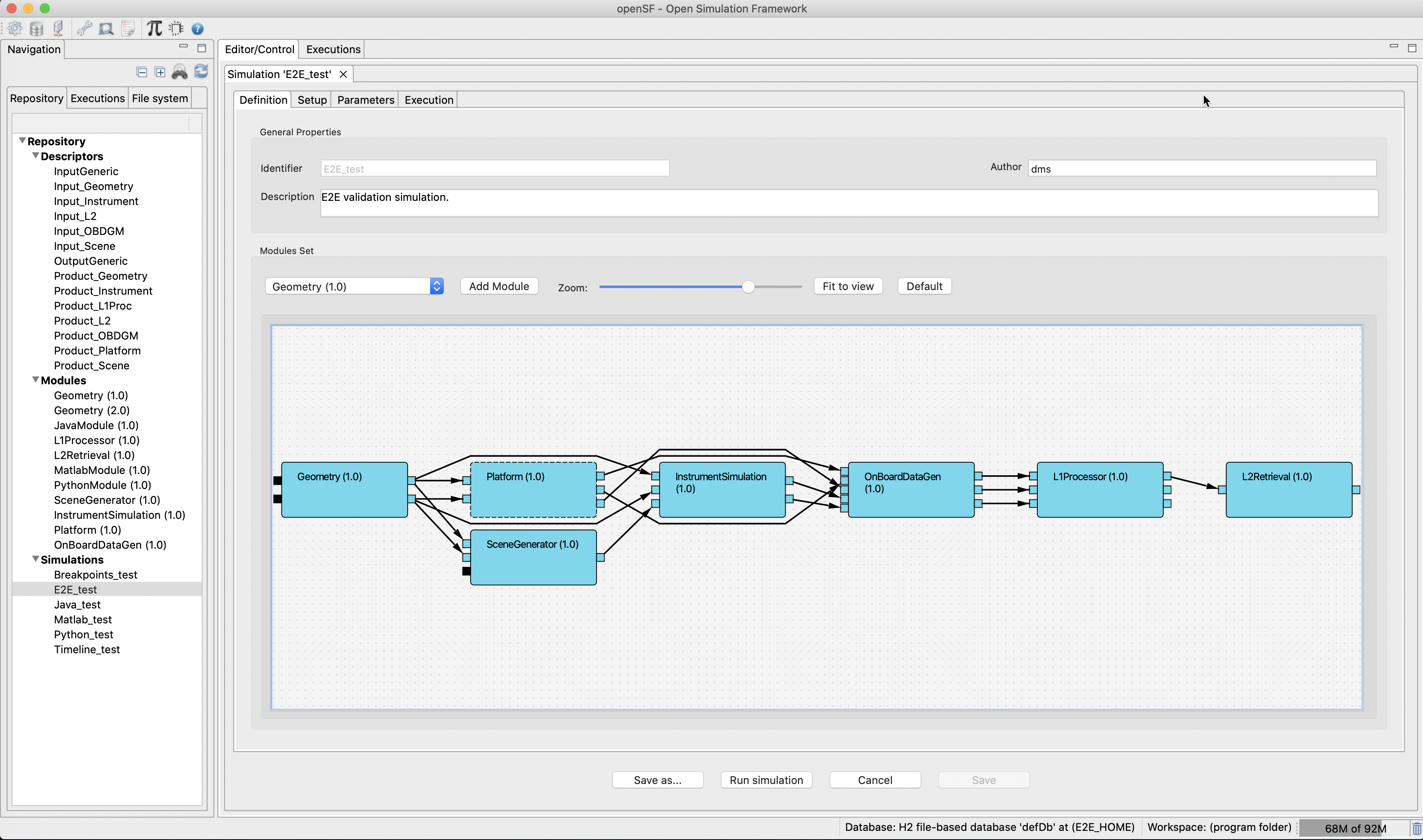
OpenSF v4.4.0 has been released and can be downloaded here.
User registration is required. Please find detailed instructions here.
New functionalities
- Pre-built OSFI packages for Python3, JAVA and MATLAB.
- ANR-299: rewrite of PE edition dialog with a new tree-based UX
- ANR-389: PE now allows parameters to be pasted into a selected group
- ANR-390: openSF parameter visibility dialog UI improvement with checkboxes
- ANR-397: openSF now prompts the user before upgrading a database
- ANR-400: update base platform to Eclipse 2024-03
- ANR-403: database files are now placed in the workspace folder by default
- ANR-404: database export files are now more interoperable between different openSF installs
Corrections
- ANR-399: different modules using the same LCF in a simulation no longer conflict
Known bugs and issues
- In macOS, table columns stop auto-resizing when their size is manually changed. This is due to a bug in the underlying Eclipse RCP, with Eclipse bug id #564840.
- ANR-339: in Linux, the simulation editor GUI can be unstable, especially while using Wayland-based graphics. A workaround is to launch openSF with the environment variable “GDK_BACKEND” set to the value “x11”.
All Release Notes are available here
A stand-alone validation tool for OpenSF XML configuration files is now available. This tool validates an XML configuration file against the specification detailed in section 2.2.6 of the Generic E2E Simulator ICD (PE-ID-ESA-GS-464). This allows to check the validity of an XML configuration without having to invoke the OSFI library.
The tool requires Python 3.8 or newer and is platform-independent. Installation and usage instructions can be found in the README.
The tool is available from the OpenSF download page (registration required) as Python wheel or source distribution package.
